Winter Storms & Extreme Cold
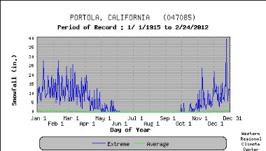
Winter storms are relatively common in the Sierra Nevada Mountains and in the Portola area. Snow accumulations of 20 to 30 inches per event can occur. The maximum daily snowfall recorded since 1/1/1915 resulted in an accumulation of approximately 40 inches (Portola Western Regional Climate Center). Severe winter storms are classified as a blizzard if wind speeds exceed 38 mph and temperatures drop to less than 21°F.
Extreme cold in the Sierras is not common, and atmospheric conditions can occur which push temperatures below 0oF. Cold air outbreaks, extreme cold, have been characterized as two or more days more in which the daily mean temperature is more than 2 standard deviations below daily mean temperature for December, January, and February. Based on data obtained from WRCC, this would indicate two consecutive days with temperatures below 5 to 10 oF. WRCC data shows extreme low temperatures reaching -30oF, but the lowest average low is about 10 oF.
Winter storms and extreme cold can knock out power, immobilize travel and hamper service crews and repair vehicles, isolate residents in remote areas, and impede access to critical facilities and goods and services. Older structures, not consistent with current code requirements, can become distressed or damaged due to large snow loads.
