Wildfire
Wildfire is an uncontrolled fire that spreads through forests, over mountains, and across deserts. Unfortunately, land use, forest management concerns, weather patterns, and climate change have altered natural fire regimes. In addition, historical practices of fire suppression are now viewed to have resulted in creating forests with large fuel loads that are primed to burn. The City of Portola is surrounded by woodlands with moderate to very high fuel loads. Physical properties of the surrounding terrain such as slope, aspect, and topographic features also impact fire behavior.
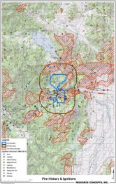
Portola has an active history of fire ignitions within the Wildland-Urban Interface (WUI), a five-mile buffer around the city. In 1988 a lightning caused fire burned 783 acres directly south of the high school, well within the city limits. In 2008 the “Cold” fire burned approximately ten square miles about fifteen miles to the west of Portola. Figure xxx, presents a graphic of fire history and ignition points for areas in and around the City of Portola. More recently, the Chips Fire ignited approximately 45 miles northwest of Portola and burned more than 75,000 acres of forested land.
Ignition risks fall into two general categories, lightning and human caused. Human caused ignitions that have occurred within the WUI come from a variety of sources: equipment use, debris burning, playing with fire, arson, and campfires. Lightning strikes, however, present the greatest ignition frequency.
